




VFR Map

Description of VFR Map
VFR Map is a navigation application designed for visual flight rules (VFR) pilots, enabling them to track their aircraft's position in real time on a detailed moving map. The app is available for the Android platform and provides numerous features tailored specifically for aviators, making it a useful tool for both flight planning and in-flight navigation. Users looking to enhance their flying experience can easily download VFR Map to access its diverse functionalities.
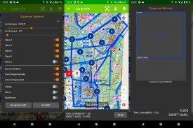
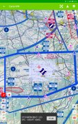
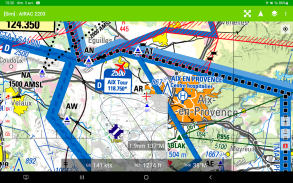
The application offers a range of map options, including geo-referenced Visual Approach Charts (VAC) and SIA France 1 maps at a scale of 1:1,000,000, covering both northern and southern regions. Pilots can select from various map layers, including their custom maps in .mbtiles format, which can be stored in the designated "MBTILES_DIRECTORY" within the app. This flexibility allows users to personalize their navigation experience based on their preferences and needs.
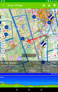
In addition to comprehensive map options, VFR Map provides real-time tracking of the aircraft's position, requiring the GPS function to be activated for accurate functionality. This feature allows pilots to monitor their current location relative to the surrounding terrain and navigational aids, which is essential for safe flying. The app also presents an altimetric profile, giving users an understanding of the elevation changes along their flight path. This information can be critical for flight planning and awareness of potential obstacles.
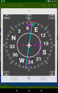
The app's dashboard is designed to display basic flight parameters, such as ground speed (GS), altitude above mean sea level (MSL), and heading. This data is presented in an easy-to-read format, allowing pilots to quickly assess their flight status without distraction. The incorporation of essential flight information contributes to situational awareness, which is crucial during flight operations.
Another significant aspect of VFR Map is its functionality in offline mode. The application retains access to previously downloaded maps and aeronautical documentation, ensuring that pilots can continue to navigate safely even without a network connection. This feature is particularly advantageous for flights in remote areas where connectivity may be limited. As all consulted information is cached, users can rely on the app during their flights without needing constant access to the internet.
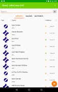
Moreover, VFR Map allows users to download aeronautical documentation in PDF format for their preferred aerodromes. This capability enables pilots to quickly access critical information, such as airport layouts and approach procedures, directly from the app. The ease of accessing such documentation can enhance flight preparation and decision-making processes.
Since version 3 of the app, various enhancements have been introduced, including improved support for geo-referenced VACs and additional mapping options. The updated version focuses on providing pilots with a richer set of tools for navigation and situational awareness. Users can also benefit from the app's caching system, ensuring that all information remains readily available, even when offline.
The application displays advertisements at a frequency of once per hour, which does not occur during flight. This implementation helps to offset operational costs associated with hosting the application while maintaining a user-friendly experience. This approach allows the developers to continue providing updates and enhancements to the app without compromising its functionality.
VFR Map serves as a valuable resource for pilots who require reliable navigation tools while flying under visual flight rules. The combination of real-time tracking, detailed mapping options, and access to aeronautical documentation equips users with the necessary resources to navigate safely and efficiently. With the ability to customize their maps and utilize the app offline, pilots can enhance their flying experience in various environments.
This application is designed to cater to the needs of aviation enthusiasts and professionals alike, streamlining the navigation process and providing essential information all in one platform. By downloading VFR Map, users gain access to a comprehensive suite of tools that facilitate safer and more informed flight operations, ultimately supporting their journey through the skies.
For additional information about VFR Map, users can explore the features and functionalities further within the app itself. The straightforward interface and useful tools make it a practical choice for anyone involved in VFR flying.


